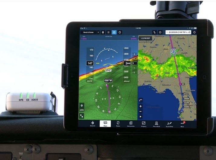
ADS-B flight tracking works by collecting aircraft position broadcasts rather than asking a website to locate a plane directly. Equipped aircraft broadcast position and other flight data that can be received by ground stations and appropriately equipped aircraft. Public tracking services may then turn collected messages into map positions.
The Federal Aviation Administration describes Automatic Dependent Surveillance–Broadcast as a system combining an aircraft position source, onboard avionics, and supporting ground infrastructure. ADS-B Out broadcasts position, altitude, ground speed, and other data about once per second. ADS-B In gives appropriately equipped pilots access to traffic information and, with compatible equipment, selected flight-information services.
A moving aircraft icon is therefore evidence of a received data stream, not an all-seeing picture of the sky. Understanding what the network measures—and what it misses—helps readers interpret online aircraft maps more accurately.
Table of Contents
What ADS-B Out Actually Broadcasts
ADS-B stands for Automatic Dependent Surveillance–Broadcast. “Automatic” means the reporting ordinarily requires no crew action during each transmission. “Dependent” refers to the aircraft using a position source, commonly satellite navigation. “Surveillance” describes its usefulness in following aircraft, while “broadcast” distinguishes the signal from a private message to a single recipient.
According to the FAA, ADS-B Out broadcasts position and other flight information about once each second. Messages can include aircraft identification, altitude, and movement details. Receivers decode these transmissions and can plot tracks over time. An online map then adds interpretation, such as airport names and aircraft types, from other databases.
ADS-B is not the same thing as conventional radar. Radar may detect aircraft by reflected radio energy, whereas ADS-B reports position information derived from avionics aboard the aircraft. Air traffic services can combine surveillance sources rather than relying on only one kind of report.
How ADS-B Flight Tracking Reaches Public Maps
Many public flight-tracking services use a distributed network of ground receivers. A receiver with a clear radio path may collect aircraft messages and forward them to a service that combines reports. Coverage varies with terrain, receiver placement, altitude, and equipment. A low-flying airplane can disappear from a public map without having disappeared from air traffic control surveillance.
A map’s callsign, route, or aircraft label may come from databases or inference rather than directly from the airplane. Operators can request limits on public display through the FAA’s Limiting Aircraft Data Displayed (LADD) program, but LADD does not switch off ADS-B radio broadcasts. Public maps are not complete official flight records.
What Pilots Can See With ADS-B In
On compatible cockpit displays, ADS-B In can show nearby traffic broadcasting ADS-B Out, including relative position and movement information. It improves situational awareness, but the picture is not complete and does not replace visual scanning, collision-avoidance procedures, or air traffic control instructions.
In the United States, FAA ground services can expand the picture. Traffic Information Services–Broadcast (TIS-B) relays certain surveillance-derived targets, while ADS-B Rebroadcast (ADS-R) can bridge two radio links. Availability depends on the aircraft’s equipment, valid transmissions, and ground coverage.
Weather is a separate service. Flight Information Services–Broadcast (FIS-B) sends selected weather and aeronautical information on the 978 MHz UAT link. A 1090 MHz-only ADS-B receiver cannot receive FIS-B weather transmissions directly.
Why Aircraft May Be Missing or Misidentified
Aircraft that do not carry or transmit compatible equipment will not necessarily appear in an ADS-B feed. Ground receiver blind spots, faulty position data, blocked signals, and flight-data processing can all affect what viewers see. Some aircraft are tracked by separate methods, but the existence of those methods does not guarantee public visibility.
A missing track is not evidence that an aircraft is in trouble. Equally, a displayed position should not be treated as a substitute for operational aviation sources during an incident. When TAD reports a diversion or emergency, the evidence should come from the operator, regulator, investigator, or clearly attributed corroborating sources.
For readers using TAD’s nearby-aircraft features, the result means “aircraft present in the available tracking data,” not a count of every aircraft overhead. Differences between tracking services can be normal because each has distinct receivers, filtering rules, and data agreements.
FAQ: ADS-B flight tracking
What does ADS-B stand for?
ADS-B means Automatic Dependent Surveillance–Broadcast, a technology used to transmit aircraft position and flight information.
Can ADS-B flight tracking show every aircraft?
No. Coverage, aircraft equipment, reception, and display restrictions can leave aircraft missing from public maps.
Is ADS-B the same as radar?
No. ADS-B transmits aircraft-derived position information, while conventional radar uses other surveillance methods.
Looking Ahead
As cockpit displays and receiver networks develop, pilots should consult current FAA ADS-B guidance for equipment and service availability. Public tracking websites should continue to disclose how coverage, aircraft identification, and data filtering affect their maps.
Sources
- FAA — Automatic Dependent Surveillance–Broadcast (ADS-B)
- FAA — ADS-B In Pilot Applications
- FAA — ADS-B Ins and Outs
- FAA — Limiting Aircraft Data Displayed (LADD)
- FAA — ADS-B Privacy and PIA
- OpenSky Network — Frequently Asked Questions